
Introduction to UAV Capabilities
Unmanned Aerial Vehicles (UAVs), commonly known as drones, have revolutionized several sectors by providing capabilities that were once restricted to manned aircraft. These machines, equipped with advanced technology, are able to perform various functions across military, surveillance, and mapping operations, making them indispensable tools in modern contexts. The evolution of UAVs has enabled them to execute complex tasks with precision and efficiency, thereby enhancing operational effectiveness.
In military applications, UAVs serve as reconnaissance tools that gather intelligence without putting human lives at risk. Their ability to operate in hostile environments has made them vital assets in gathering real-time battlefield data, which contributes crucially to strategic planning. Similarly, in surveillance operations, these versatile platforms facilitate long-range aerial observation, allowing for the monitoring of vast areas with minimal human intervention. Technologies like thermal imaging UAV enhance visibility in low-light conditions, transforming the UAV into an effective surveillance tool capable of identifying subjects even in challenging scenarios.
Furthermore, drone technology has also made significant inroads into mapping and surveying applications. Multi-sensor UAV payloads can collect data across various wavelengths, providing comprehensive insights that support infrastructure development and environmental monitoring. This versatility is especially evident in all-weather UAV systems, which are designed to perform under diverse meteorological conditions, further broadening their operational scope. These advancements underscore the critical role that UAVs play in collecting and analyzing data across multiple domains, positioning them as key components of contemporary operational strategies.
Understanding Thermal Imaging Technology
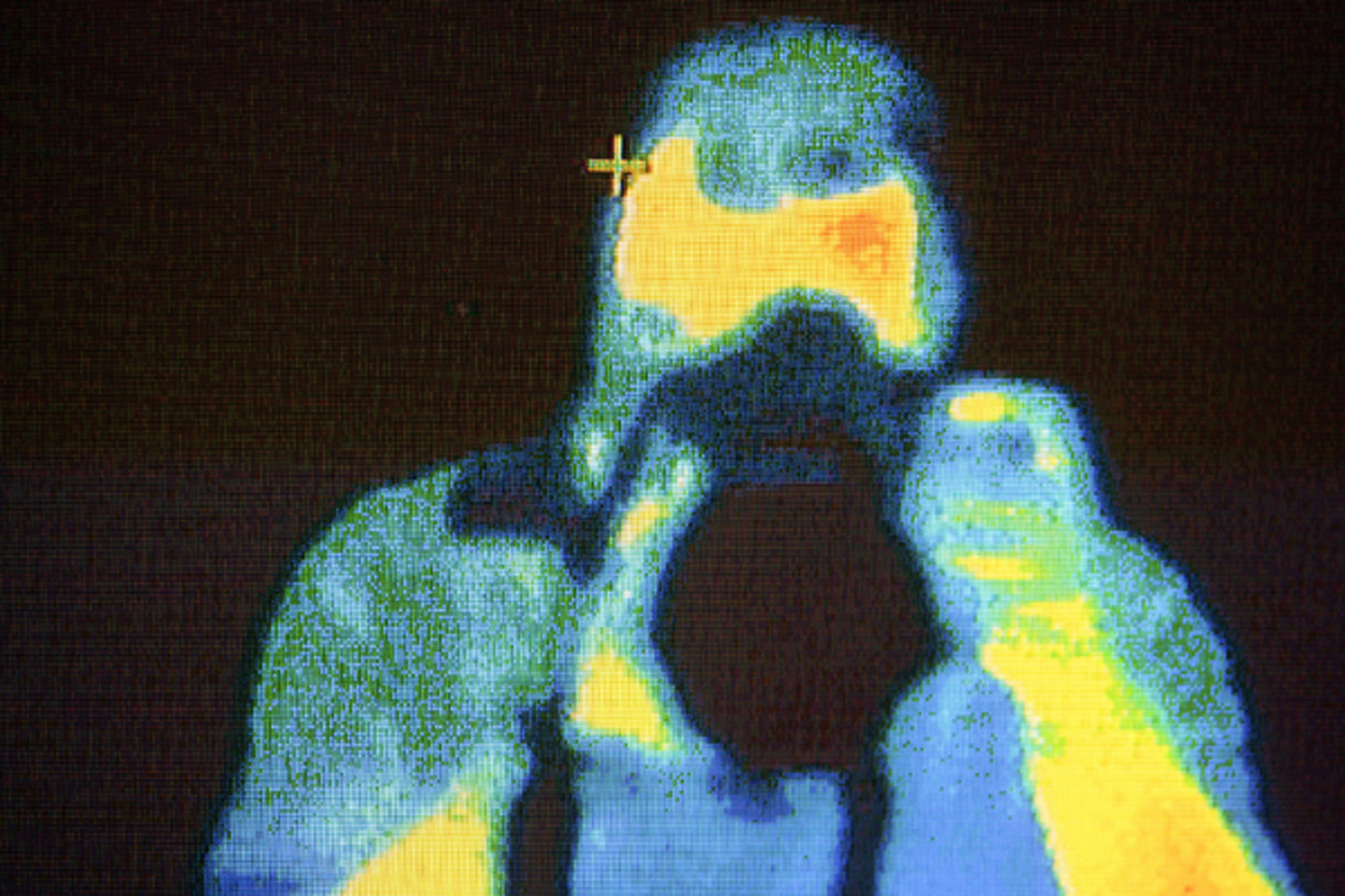
Thermal imaging technology has revolutionized long-range aerial observation by enabling the detection of infrared radiation emitted by objects. Unlike traditional imaging systems that rely on visible light, thermal imaging captures the heat signatures of subjects, thereby creating thermal pictures that can be interpreted by operators. This functionality is especially crucial in low-visibility conditions such as nighttime or adverse weather, where conventional visual means may fail.
The core mechanism of thermal imaging involves the use of specialized sensors that can detect infrared radiation. These sensors convert the thermal energy emitted by an object into electronic signals, which are then processed to produce an image. This process allows the identification of living beings and objects, even in complete darkness. The technology is widely utilized in UAVs, enhancing their ability to perform surveillance and reconnaissance missions with high precision.
In practical applications, the integration of thermal imaging UAV capabilities proves invaluable. For instance, search and rescue operations can be notably improved, as the thermal cameras can locate individuals by detecting their body heat, even when they are obscured by smoke, fog, or dense foliage. Additionally, thermal imaging facilitates monitoring of critical infrastructures such as power lines and pipelines, as it can identify overheating components before they fail, thereby preventing hazards.
The advantages of employing thermal imaging in UAVs extend beyond visibility; they also encompass a significant increase in operational effectiveness. With a multi-sensor UAV payload that includes thermal imaging capabilities, operators can gather a wealth of information from great distances, effectively enhancing situational awareness in various scenarios. Overall, the combination of thermal imaging with UAV technology signifies a substantial advancement in surveillance and monitoring applications in environments that require all-weather UAV systems.
The Basics of Laser Rangefinding
Laser rangefinding technology plays a crucial role in enhancing the capabilities of unmanned aerial vehicles (UAVs), especially in reconnaissance and targeting applications. At its core, laser rangefinding operates by emitting laser beams towards a target and measuring the time it takes for the reflected beam to return to the sensor. This precise measurement allows for accurate distance calculations, which is vital for various UAV operations. By determining the exact distance to a target, UAV operators can enhance situational awareness and optimize engagement strategies during missions.
In reconnaissance missions, accurate distance measurements provided by a laser rangefinder drone can significantly enhance the effectiveness of surveillance activities. For example, when deployed alongside a thermal imaging UAV, the integration of rangefinding technology allows operators to better assess the dimensions and distance of objects in low-visibility conditions. This synergy ensures that the UAV can operate effectively, irrespective of environmental factors such as fog or rain.
Moreover, as UAVs are often tasked with long-range aerial observation, laser rangefinding contributes to improved targeting accuracy. The precise data obtained through laser-based measurements enables UAVs equipped with a multi-sensor UAV payload to distinguish between multiple targets within a single field of view. This is essential in military operations where miscalculations can lead to significant operational failures.
Incorporating laser rangefinders into an all-weather UAV system furthers the potential for operations in adverse conditions. These systems ensure reliable data collection even in challenging environments, ultimately enhancing the decision-making process for UAV operators. The integration of laser rangefinding technology with other sensors maximizes the effectiveness of UAV missions, promoting successful outcomes in various applications.
In the realm of unmanned aerial vehicles (UAVs), achieving a comprehensive understanding of the environment often necessitates the integration of various sensor technologies. This is where the concept of sensor fusion becomes paramount. Sensor fusion involves the merging of data from different sensors to provide a more accurate and reliable representation of the surroundings, particularly in low-visibility conditions where traditional visual data may be compromised.
One prominent application of sensor fusion is combining thermal imaging installed on UAVs with data obtained from a laser rangefinder drone. While thermal imaging provides critical insights into heat signatures, allowing operators to detect living entities and differentiate between various materials, a laser rangefinder enhances this capability by providing precise distance measurements. Together, these technologies enable the formation of a multi-dimensional perspective of the landscape, which is especially beneficial in long-range aerial observation tasks.
Furthermore, the integration of a multi-sensor UAV payload facilitates the simultaneous capture of these complementary data types, leading to improved situational awareness. In scenarios marked by environmental complexity and limited visibility—such as nighttime operations or inclement weather—combining thermal imaging with laser rangefinders helps to counteract the limitations of individual sensing modalities. The resultant data allows for informed decisions based on a more comprehensive overview of real-time conditions.
An all-weather UAV system equipped with integrated sensors ensures that operators can maintain efficiency and accuracy in diverse operational environments. The synergistic effect of sensor fusion thus enhances the UAV’s capability for not only surveillance but also data gathering and reconnaissance missions, significantly improving response strategies in low-visibility scenarios. This capability proves essential for military applications, search and rescue operations, and various industrial uses where precision and reliability are paramount.
Real-Time Measurement and Its Importance
The integration of advanced sensors in thermal imaging UAVs, along with laser rangefinder drones, has revolutionized the field of aerial surveillance, particularly in low-visibility environments. Real-time measurement capabilities provided by these multi-sensor UAV payloads are critical for effective surveillance and reconnaissance missions. The ability to capture and analyze data instantaneously allows operators to respond quicker to emerging situations, ultimately enhancing the overall mission effectiveness.
Real-time data acquisition allows for immediate assessment of changing conditions. For example, during a search and rescue operation, the information gathered by a thermal imaging UAV can identify potential victims in obscured landscapes without delay. Similarly, the use of laser rangefinders improves the precision of distance measurements, enabling operators to ascertain the location of objects or changes in the environment almost instantaneously. This capability reduces response times significantly, which can be vital in critical scenarios such as natural disasters or security emergencies.
Moreover, the implementation of an all-weather UAV system enhances the consistency of real-time data collection across varied environments and conditions. Regardless of rain, fog, or nighttime operations, operators can rely on the thermal imaging technology to deliver crucial insights. Such real-time monitoring supports tactical decision-making and elevates situational awareness, ensuring that every intel mapping process is as informative as possible.
In essence, real-time measurements from thermal imaging UAVs and laser rangefinder drones are indispensable for modern aerial surveillance. The effectiveness of these advanced systems lies in their ability to provide timely and accurate information, enabling rapid responses and contributing to successful mission outcomes.
Integrating Technologies into a Single Stabilized Payload
The advancement of drone technology has significantly evolved the integration of various sensor systems, allowing for enhanced capabilities in thermal imaging UAVs. One of the most notable developments is the engineering behind multi-sensor UAV payloads that combine thermal, optical, and ranging technologies, enabling long-range aerial observation in challenging conditions. By employing a unified, stabilized payload, UAVs are now capable of delivering real-time, precise data collection in low visibility scenarios, showcasing their versatility across numerous applications.
Stabilization is a critical challenge when integrating multiple sensors in a single platform, particularly considering the variations in operational environments. High-maneuverability flights can lead to motion-induced errors that compromise image quality and data accuracy. Therefore, advances in stabilization systems are essential. These systems often employ gimbals or other mechanical methods that counteract drone movements, thus ensuring that the data captured remains reliable. The technology allows UAVs to maintain stable imaging, whether utilizing a thermal imaging UAV for surveillance or engaging a laser rangefinder drone for distance measurements.
Moreover, the interplay between different sensor types amplifies the capabilities of all-weather UAV systems. For instance, the synergy between thermal imaging and laser rangefinders facilitates the generation of comprehensive situational awareness, which is invaluable in both military and civilian applications, such as search and rescue operations. An integrated system can enable operators to assess image data while simultaneously gauging distances and detecting obstacles, thus enhancing navigational precision and operational safety. The integration of such advanced sensor technologies within a single platform marks a significant step forward in aerial reconnaissance and surveillance capabilities.
Advantages of Combined Sensor Systems
The integration of various sensor technologies into UAV systems has emerged as a transformative approach, significantly enhancing their operational capabilities, especially in long-range aerial observation and surveillance operations. During missions that require a high degree of accuracy and versatility, the use of combined sensors—such as thermal imaging UAVs paired with laser rangefinder drones—enables operators to collect data under challenging conditions, including low visibility scenarios.
One of the most notable advantages of this integration lies in its ability to improve target detection and classification. Thermal imaging technology allows for the identification of heat signatures, making it possible to locate targets that are otherwise obscured by environmental factors, such as fog or smoke. Coupled with a laser rangefinder drone, the UAV can measure distances with remarkable precision, thus enhancing situational awareness and providing critical data for decision-making. This synergy not only amplifies the efficacy of individual sensors but also ensures comprehensive surveillance coverage.
In multiple industries, from defense to agriculture, the operational advantages of employing a multi-sensor UAV payload are substantial. In agricultural contexts, for instance, operators can utilize the thermal imaging capabilities to monitor crop health while using laser rangefinders to map topography for better resource allocation. In defense and security sectors, the all-weather UAV system becomes instrumental in conducting surveillance missions that require 24/7 operational capacity, ensuring that stakeholders remain informed and responsive to any developments.
Overall, the benefits of combining different sensor technologies open avenues for highly specialized applications that enhance efficiency and operational scope, cementing the role of advanced UAV systems in modern aerial operations.
Case Studies of UAV Operations with Enhanced Sensors
The introduction of thermal imaging UAVs and laser rangefinder drones has revolutionized various industries, notably in areas requiring long-range aerial observation and low-visibility capabilities. A prominent case study demonstrating the efficacy of a multi-sensor UAV payload occurred during a night-time search and rescue operation in a dense forested region. Equipped with a thermal imaging UAV, the team was able to identify heat signatures of missing individuals even amidst low-temperature environmental conditions. This capability allowed for precise targeting and timely interventions of rescue teams, showcasing how advanced imaging technology can enhance the effectiveness of UAV operations.
Another compelling instance involved a military application where a laser rangefinder drone was deployed for surveillance missions over hostile territories. The long-range capabilities of this UAV system allowed for the collection of real-time data while minimizing the risk to personnel. By utilizing its laser rangefinder, the drone provided accurate distance measurements to targets, enabling artillery units to plan their operations with greater precision. This case exemplifies the significant role that enhanced UAV sensors play in strategic military operations, particularly in low-visibility situations.
In commercial applications, companies have also recognized the potential of all-weather UAV systems for infrastructure inspection. For instance, a thermal imaging UAV was used to assess the integrity of power lines during adverse weather conditions. The UAV’s ability to operate effectively in rain and fog, combined with its real-time thermal imaging capabilities, allowed for the identification of overheating components, ensuring swift maintenance and reducing downtime.
These case studies highlight the critical role that advanced sensing technology plays in enhancing UAV capabilities. By integrating thermal imaging and laser rangefinding, these systems not only improve operational efficiency but also expand the operational envelope for various missions, proving indispensable in both civil and military domains.
Conclusion and Future Considerations
The integration of thermal imaging UAV and laser rangefinder drone technologies has significantly revolutionized the field of aerial surveillance, particularly in low-visibility situations. These advanced systems enhance long-range aerial observation capabilities, allowing operators to gather critical data even under challenging environmental conditions. The ability to deploy a multi-sensor UAV payload not only increases the versatility of unmanned aircraft but also offers enhanced situational awareness to users in various applications such as military operations, search and rescue missions, and environmental monitoring.
As advancements in these technologies continue, we can expect a breadth of innovation that will further refine UAV operations. The development of all-weather UAV systems that incorporate thermal imaging and laser rangefinding capabilities will provide unprecedented access to real-time data collection. Such developments are anticipated to improve the safety and effectiveness of aerial missions while ensuring higher precision in target acquisition and analysis.
Looking ahead, the importance of sensor integration cannot be overstated. Future UAV models may feature sophisticated algorithms for fusing data from multiple sources, resulting in a more comprehensive understanding of the operational environment. Furthermore, as the demand for autonomous operations grows, it is plausible that innovations in artificial intelligence will be deployed to enhance drone functionalities in thermal imaging and laser rangefinding.
In conclusion, the fusion of thermal imaging and laser rangefinder technologies in UAV systems represents a pivotal advancement in aerial surveillance. These capabilities are set to evolve further, paving the way for more efficient, reliable, and user-friendly UAV applications in the years to come. Stakeholders in this field should stay informed about emerging trends and innovations to fully leverage the potential of these transformative technologies.